
OZ 2.0 Nominations: All 56 Jurisdictions Have Submitted, but Only Half Have Published Their Lists
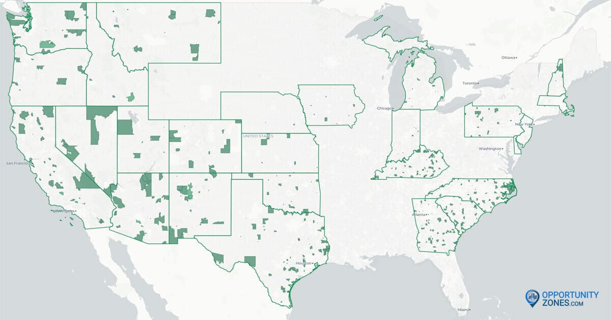
Every state, the District of Columbia, and all five U.S. territories have now submitted their OZ 2.0 tract nominations to the U.S. Treasury Department. But only 28 of those 56 jurisdictions have published their lists.
The Opportunity Zone nomination window closed on October 28 for states that didn't opt out of Treasury's automatic 30-day extension. Since then, we've been tracking down every published list we can find. Some came from press releases and PDFs. Others turned up only after some sleuthing in state ArcGIS accounts, where lists sat in public map layers that no state web page linked to.
Our live OZ 2.0 nominations map now shows 3,609 nominated tracts across 28 jurisdictions. That's about 55% of the roughly 6,576 designations expected nationwide, and it's the most complete public view so far of where the next round of Opportunity Zones will land. (For background on the 90-day nomination deadline, see our earlier update, OZ 2.0 Nominations: Where Things Stand After the 90-Day Deadline.)
The map draws on official state announcements, published lists, and state-maintained GIS data. Where a state hasn't confirmed that its public data matches what it sent Treasury, we note that below. Treasury certification is the final word.
The 28 Jurisdictions That Have Published
California (620 tracts) and Texas (608) alone account for 1,228 of the 3,609 nominated tracts on the map, about a third of the total. Five smaller states (Alaska, Delaware, Idaho, Montana, and New Hampshire) each nominated 25 tracts.
Jurisdiction | Nominated Tracts |
|---|---|
25 | |
127 | |
620 | |
91 | |
25 | |
238 | |
25 | |
126 | |
44 | |
53 | |
137 | |
104 | |
215 | |
25 | |
28 | |
49 | |
25 | |
130 | |
65 | |
202* | |
104 | |
58 | |
218 | |
113 | |
608 | |
18 | |
37 | |
99 | |
Total | 3,609 |
*North Carolina submitted 204 tracts but has published only 202. Its cap rose to 204 in late September, when the IRS adopted Alternate Framework 1, and the two additional tracts it submitted on October 28 have not been made public.
How We Found Them
Several of these lists first turned up in public map layers on ArcGIS Online, the mapping platform most state agencies use, before any state web page linked to them. We pulled the tract IDs straight from each state's own data.
- Michigan (215): The Michigan Economic Development Corporation posted a map layer with its nominated tracts on October 30.
- Montana (25): The Montana Department of Commerce posted a layer titled "Montana Designated Opportunity Zones 2.0" on October 30, with every tract marked "Selected by Governor."
- Nevada (49): The tracts come from the Nevada Governor's Office of Economic Development's draft nomination list, revised the day after the deadline to swap out five tracts that weren't eligible. The office still labels it a draft, but we believe it matches what Nevada submitted.
- North Carolina (202 of 204): The list comes from a North Carolina Department of Commerce layer of tracts selected for OZ 2.0 designation, last edited September 14. North Carolina's cap rose to 204 in late September, when the IRS adopted Alternate Framework 1. The state submitted its two additional tracts on October 28, but these last two tracts haven't been published yet.
- South Carolina (113): When the state's cap rose from 112 to 113, we confirmed the added tract (in Lee County) and two late same-county swaps by querying the state's live map layer.
Every list was checked against the source's own record counts before it went on the map.
The 28 Jurisdictions That Haven't Published
The other 28 jurisdictions have submitted nominations but haven't released a final list. They include some of the largest OZ markets in the country: New York, Florida, Illinois, and Ohio.
In several cases, though, there are strong clues to what was submitted.
Likely final, but unconfirmed
- North Dakota (25): The North Dakota Department of Commerce published a map layer labeled
final_recson October 14 with 25 tracts, equal to the state's cap. No announcement confirms it, so we've left it off the map for now.
Public draft or recommended lists
- Arkansas (78): The Arkansas Economic Development Commission's recommended tracts from August 27, equal to the state's cap.
- Connecticut (61): The Connecticut Department of Economic and Community Development's recommended tracts from September 17, equal to the cap, with a rationale for each tract.
- District of Columbia (25): The Office of the Deputy Mayor for Planning and Economic Development's preliminary picks from July, released for public comment.
- Ohio (130): An internal review draft covering only seven metro counties. Ohio's allocation is 260, so this is half the list at best.
- Vermont (25): The Vermont Agency of Commerce and Community Development's July recommendation.
- Wisconsin (86): The Wisconsin Economic Development Corporation's scored shortlist of 75 primary tracts and 11 alternates. Wisconsin's cap is 77.
Partial clues only
- Louisiana: A regional list covering seven Acadiana parishes, not a statewide slate.
- Missouri: A list of 221 tracts submitted by local applicants, which is neither a draft nor a selection.
- Wyoming: Only 20 tracts in the state are eligible, so if Wyoming nominated every eligible tract, the eligible list is the nominated list.
Nothing public yet
Alabama, American Samoa, Florida, Guam, Hawaii, Illinois, Maine, Maryland, Minnesota, Mississippi, New York, Northern Mariana Islands, Puerto Rico, Rhode Island, South Dakota, Tennessee, Virginia, and West Virginia.
What Happens Next
Treasury has 30 days from the end of each state's nomination window to certify its nominations, and a state can request 30 more. For states whose window closed October 28, that means certification by November 27, or by late December with the extra 30 days. The new zones take effect January 1, 2027.
So far, Treasury designations have been confirmed in five jurisdictions: California, Georgia, Idaho, Nebraska, and New Hampshire. The actual number is likely much higher, since not every state announces when Treasury certifies its nominations.
Our map and the lists in this article are still preliminary and subject to change until Treasury publishes its official list of designated zones. We don't expect many changes, if any. We also expect Treasury to publish that list later this month (possibly as soon as next week), well ahead of the late-December deadline.
We'll keep adding jurisdictions to the map as their lists surface, and you can follow each state's status on our OZ 2.0 State Tracker. Once Treasury finalizes designations nationwide, we'll publish the complete map of all 56 jurisdictions.
Explore the Live Map
See all 3,609 nominated tracts across the 28 published jurisdictions on our live OZ 2.0 nominations map. Zoom in to any state, click a tract for its details, and check back as more lists come in.